Florence Historic Centre Map Guide: Zones, Landmarks, and Navigation
Use this Florence historic centre map guide to navigate the five key anchors, four main zones, and walking connections without ever getting disoriented.
The historic centre of Florence is small enough to cross entirely on foot in under 30 minutes. That compactness is one of its great virtues as a travel destination. It is also the source of one of its main challenges: the streets do not follow a modern grid. They follow patterns laid down in the Roman period and reorganised in the medieval period, which means turns that look logical on paper lead to dead ends, and addresses can be maddeningly hard to find without a reference point.
This guide breaks the centre into navigable zones, identifies the five landmarks that work best as orientation anchors, explains how the areas connect on foot, and suggests the digital tools that work reliably in the city.
Understanding the shape of the centre
The historic centre occupies a bend in the Arno river. The river defines the southern edge. The rough perimeter on the other three sides follows the line of the 14th-century city walls, most of which were demolished in the 19th century but can still be traced on detailed maps.
From east to west, the centre stretches approximately 2.5 kilometres. From north to south, at its widest point, it is about 1.5 kilometres. This is a compact area. A brisk walker can reach any point from any other point in under 30 minutes.
The main axis for orientation purposes runs north to south along Via dei Calzaiuoli, a largely pedestrianised street that connects Piazza del Duomo at the north end to Piazza della Signoria at the south end. This 600-metre stretch is the spine of the tourist circuit and the clearest line to hold in your head when navigating.
The secondary axis runs roughly east to west along Via dei Tornabuoni and Via Porta Rossa, linking the area near the train station with the Bargello and the Santa Croce neighbourhood in the east.
The five orientation anchors
These five points form a mental framework that makes the rest of the centre navigable. You do not need to memorise streets if you can locate these in relation to each other and to where you are standing.
Piazza del Duomo. The religious centre of medieval Florence and the most visually prominent cluster in the city. The Duomo (Cathedral of Santa Maria del Fiore), Giotto’s Campanile, and the Baptistery of San Giovanni all sit within a few metres of each other here. The dome is visible from most elevated points in the centre and from several streets, which makes it useful as a compass reference even when you are not near it.
Piazza della Signoria. The civic centre, 600 metres south of the Duomo along Via dei Calzaiuoli. Palazzo Vecchio, the Loggia dei Lanzi, and the entrance to the Uffizi gallery are all here. This is where political authority was concentrated in the Florentine Republic and where the main public events of Florentine history, executions, proclamations, uprisings, and celebrations, took place.
Ponte Vecchio. The oldest surviving bridge over the Arno, roughly 300 metres west of the Uffizi. It is the main pedestrian crossing point between the north bank of the historic centre and the Oltrarno neighbourhood on the south bank. The bridge is built over with goldsmiths’ shops that date the current arrangement to a 1593 decree by Ferdinando I de’ Medici, who removed the butchers and tanners who had previously occupied it.
Santa Maria Novella station. The principal train station sits at the northwestern corner of the historic centre. It is not a monument but it functions as the most reliable practical anchor for most visitors, who arrive through it and return to it. From the station, every major sight is between 10 and 25 minutes on foot.
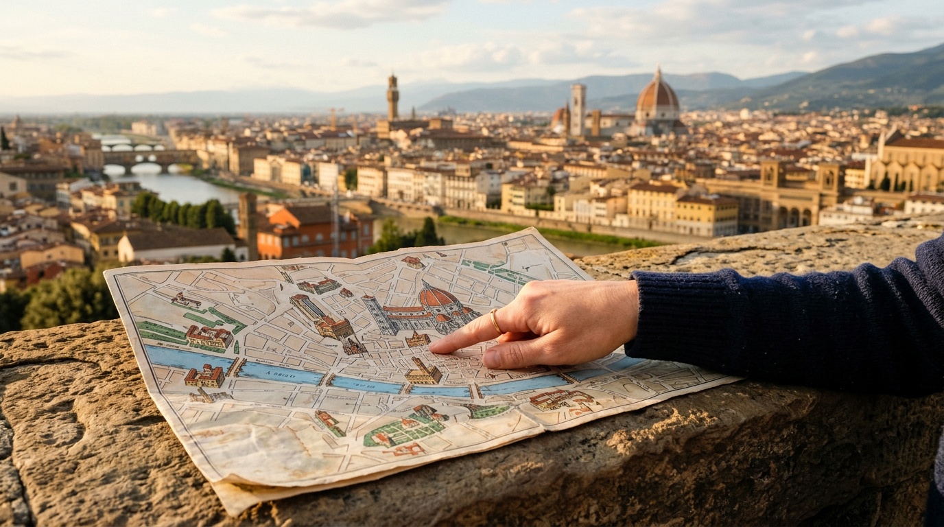
Piazzale Michelangelo. This viewpoint on the hillside south of the Arno is not inside the historic centre, but a visit there should be near the top of any itinerary for a practical reason: standing at the balustrade and looking north gives you the complete spatial layout of the city in a single glance. You can see the Duomo, the Arno with its bridges, the hills around the centre, and the relation of one landmark to another in a way that no map fully conveys.
The four zones and what they contain
The centre divides into four overlapping zones, each with a distinct character and concentration of specific types of attractions.
The Duomo zone covers the area around Piazza del Duomo and runs north toward the Accademia and San Marco. This is the most heavily visited section of the city. The Accademia at Via Ricasoli 58 houses Michelangelo’s David (open Tuesday to Sunday 08:15 to 18:50, entry 12 to 16 euros depending on season, advance booking strongly recommended). San Marco is a former Dominican convent with Fra Angelico’s cell frescoes (open Tuesday to Friday 08:15 to 13:50, weekends 08:15 to 16:50, entry 4 euros). The best time to visit this zone is between 08:00 and 10:00, before the large group tours arrive.
The Signoria zone covers Piazza della Signoria, the Uffizi, the Bargello, and extends east to Piazza Santa Croce. The Uffizi (open Tuesday to Sunday 08:15 to 18:50, entry 20 to 25 euros, advance booking essential) is the primary art museum. The Basilica di Santa Croce at the eastern end of this zone (open Monday to Saturday 09:30 to 17:30, Sunday 12:30 to 17:30, entry 8 euros) contains the actual tombs of Michelangelo, Galileo, and Machiavelli alongside the cenotaph of Dante.
The Santa Maria Novella zone extends from the station westward to Via dei Tornabuoni and covers the luxury shopping district and the church of Santa Maria Novella itself. The church (open Monday to Thursday 09:00 to 19:00, Friday 11:00 to 19:00, weekends 13:00 to 17:30, entry 7.50 euros) contains important frescoes by Masaccio, Ghirlandaio, and Filippino Lippi. This zone is slightly less crowded than the Duomo area and more practical for shopping or an afternoon coffee.
The San Lorenzo zone sits northwest of the Duomo and contains the Mercato Centrale, the church of San Lorenzo (open Monday to Saturday 10:00 to 17:00, entry 7 euros), and the Medici Chapels at Piazza Madonna degli Aldobrandini 6 (open Tuesday to Saturday 09:00 to 13:45, entry 9 euros). The outdoor market along Via dell’Ariento and Via Sant’Antonino is a large leather goods and souvenir market, open daily from 09:00 to 19:00.
Moving between zones on foot
Inside the ZTL (the restricted traffic zone that covers most of the historic centre), walking is the correct and only practical method of travel. The main pedestrian thoroughfares are Via dei Calzaiuoli (the north-south spine), Via Roma (which connects the station to the Duomo), and Borgo dei Greci (which runs east from Piazza della Signoria toward Santa Croce).
For crossing to the Oltrarno district south of the Arno, the four main bridges offer different experiences. Ponte Vecchio is the most central and the most crowded. Ponte Santa Trinita, immediately west of Ponte Vecchio, provides the best view back toward Ponte Vecchio itself and is often used for photographs. Ponte alle Grazie is east of the Uffizi and useful for approaching San Nicolo and the hillside neighbourhoods. Ponte alla Carraia is west of Santa Trinita and connects to the quieter western sections of Oltrarno.
For Piazzale Michelangelo and San Miniato al Monte, bus line 13 runs from Lungarno Serristori every 30 to 40 minutes and costs 1.70 euros. The walk from Ponte Vecchio to Piazzale Michelangelo takes about 20 to 25 minutes uphill.
Digital tools and paper maps
The free paper map available from most hotels in the centre covers the main landmarks accurately. For more detailed navigation, Google Maps works reliably within the historic centre. Downloading the relevant area offline before travel is advisable, since signal can be weak inside large buildings and in the narrower streets.
Maps.me offers offline navigation with walking routes and includes specific street-level detail useful for finding addresses in the denser parts of the centre. It is particularly helpful in the San Lorenzo zone, where the street market can make street signs difficult to locate.
The ATAF app provides live bus routes and departure times and allows direct ticket purchase. The tourist information office near Santa Maria Novella station and the office at Piazza della Repubblica carry current printed maps with opening hours and transport routes.
Where to Stay in Florence
The Key is positioned at Via Cittadella 22, in the Santa Maria Novella zone at the western edge of the historic centre, just five minutes on foot from the station. That location places all four zones described above within comfortable walking distance, making it a practical base for any combination of the itineraries in this guide. Full details at The Key.